


The Netflix series set in Yosemite didn’t film there, so our national parks columnist shares its overlooked places that deserve the spotlight.
“Untamed,” a Netflix series, is set in Yosemite National Park but was primarily filmed in British Columbia, Canada. (Photo: Courtesy of Netflix © 2025)
Published August 8, 2025 03:00AM
Yosemite National Park is gorgeous. That was my first impression when I watched the pilot of Untamed, the Netflix drama that follows a ranger investigating a murder inside one of the most iconic parks in the country. A lot of viewers—and National Park experts— expressed frustration with the show, mostly because the producers got a lot of the details wrong, from the human history of the park to the depiction of search and rescue procedures. Oh, and the fact that the majority of the show wasn’t even filmed inside Yosemite is a major point of contention. Most of the show was filmed in British Columbia, Canada, and according to Netflix, stand-ins included Mount Seymour and Callaghan Valley in Whistler. But the opening scenes of the first episode prominently features Yosemite Valley with a couple of dramatic bird’s eye view angles of the park’s granite that are absolutely mesmerizing.
I saw the opening sequence and I didn’t care what the rest of the show was about. I just wanted to see more of that landscape. John DeGrazio, founder of YExplore, a guide service in Yosemite National Park that specializes in photography hikes, understands the allure of that landscape.
“I was drawn in by the Valley during my first visit in 2003, so much so that my wife and I decided to move here without knowing a soul,” DeGrazio says. “I had visited a lot of other national parks, but Yosemite has this intrinsic magic to it. John Muir nailed it when he said the Valley was unparalleled.”
Beyond Yosemite Valley, Landscapes That Deserve the Spotlight
It’s dramatic landscapes make a intriguing setting for TV show, even a melodrama that gets a lot of the details wrong. But here’s the thing about Yosemite National Park: the landscape is just as stunning when you leave the Valley.
“The Valley is only percent of the park,” DeGrazio says. “Start walking away from the crowds and not only will you find solitude, you’ll find more granite domes and meadows and lakes…the diversity of landscape inside the park gives you a variety of scenes with a lot of awe factor. Anywhere you turn, you can find a sense of magic.”
Half Dome, El Capitan, Yosemite Falls … you could spend a lifetime staring at these landmarks from the Valley floor, but you’d miss out on some of the most amazing views in the park. Here are seven of the most photogenic scenes, from the edge of Yosemite Valley to the park’s less-crowded backcountry that deserve the spotlight, too.
Cathedral Lakes
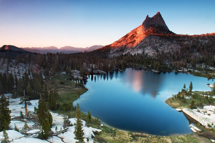
There are more than 3,200 natural lakes inside Yosemite National Park, but a solid argument could be made that Cathedral Lakes, a watery duo in the High Sierra near Toulomne Meadows, are the fairest of the bunch. The 10,916-foot tall Cathedral Peak rises directly from the edge of Upper Cathedral Lake, while Lower Cathedral has broad expanses of sloping granite dropping down to its shore. Lower Cathedral also offers an expansive view of the Sierra High Country, including Tenaya Lake, from its shore.
How to Get There
Reaching the Cathedral Lakes requires a nine-mile hike out and back on a piece of the John Muir Trail from the Cathedral Lakes Trailhead, in the Tuolumne Meadows area. It’s a popular trailhead, but the crowds will be nothing like what you experience inside the Valley. The hike itself would be a worthy adventure even if it didn’t end at a couple of gorgeous lakes, as it passes through meadows and requires the occasional creek crossing. A half-mile spur trail leads to Lower Cathedral, which is the more popular destination, but I say visit both.
North Dome
North Dome itself is an impressive piece of granite, rising to 7,546 feet along the northern rim of Yosemite Valley, but you want to summit this mountain because of its view of a more famous piece of granite, Half Dome, which is directly across the Valley floor. Some have made the argument that the view of Half Dome from North Dome is the best in the park. Maybe. You’ll also get to see El Capitan and Clouds Rest from this perch, not to mention a huge chunk of the Valley itself. This is a great alternative to hiking Half Dome or Clouds Rest.
How to Get There
The easiest way to reach North Dome is a nine-mile hike out and back from Tioga Pass from the Porcupine Creek Trailhead. You’ll bounce from forest to meadow until reaching the base of North Dome, then it’s a ramble along rounded granite to the summit. You’ll start seeing Half Dome as soon as you hit the granite, but keep going to the sloping edge for the best view. You’ll also have the option to take a 0.3-mile side hike to Indian Rock, Yosemite’s only natural arch.
Merced Grove of Giant Sequoias
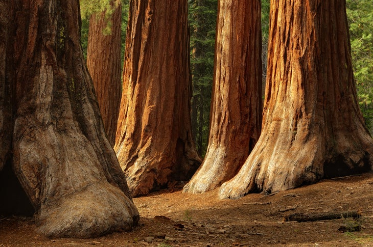
Giant sequoias are the largest known trees in the world, with canopies that can stretch 300 feet towards the sky and trunks that can be 30 feet around. These are the massive redwoods that can be found on the slopes of the Sierra Nevada Mountains, and Yosemite National Park has three giant sequoia groves. The Merced Grove is the smallest of the lot, with about 20 behemoth trees. But its trees are just as big, if not bigger, than the other two groves and it’s the least crowded of the three forests, which means the photo you take of your hiking partner hugging a tree will be unique. The redwoods are scattered throughout a small area of forest, but there’s a cluster of five of them flanking the trail that makes for an awesome photo.
How to Get There
Hike the three-mile hike out and back on an old road bed from the Merced Grove Trailhead off of Big Oak Flat Road. It’s an easy hike during the warm months, or a challenging snowshoe or cross country ski during the winter. You’ll pass an old ranger cabin, which used to be the superintendent’s vacation cabin, along the way.
Sentinel Dome
You like mountains with 360-degree views? Sentinel Dome might have the best 360 view in the entire park, with something dramatic in almost every direction you look. Stand on top of Sentinel and you’ll see Yosemite Falls and El Capitan to the north, Nevada Falls and Half Dome to the east, and the Merced Canyon to the west. The view of Yosemite Falls is particularly good. That 2,425-foot waterfall has sections that are obscured from most vantage points, but you can see almost the entire ribbon of water from Sentinel.
How to Get There
It’s a 2.2-mile out and back hike on the Sentinel Dome Trail, off of Glacier Point Road. You’re not going to have the view to yourself, but it’s nice to share pretty things. You can tack on an extra couple of miles and create a five-mile loop that takes in Taft Point for another great view of El Capitan. If you can time your hike for sunset, and bring a headlamp for the hike back to your car, you won’t be sorry.
Gaylor Lakes
Remember when I said Cathedral Lakes were arguably the prettiest of Yosemite’s ponds? Gaylor Lakes are the other side of that argument. There are five different lakes inside this high elevation valley, all of which are surrounded by some combination of lush meadows, tan boulders, and granite ridges. So take your pick of photo opportunities here. Middle Gaylor Lake is flanked by sloping granite on one side and lush meadow on the other. Small, gray boulders dot the grassland and taller mountains, including Cathedral Peak, rise on the horizon. It’s a stunner. But you’ll also get to see Upper Granite Lake, which is nestled in the bottom of a dramatic bowl, and Lower Granite Lake, a narrow affair offering views of distant peaks.
How to Get There
It’s a three-mile round trip on the Gaylor Lakes Trail off of Tioga Road. It’s relatively easy going two-mile out and back with all kinds of eye candy along the way. Loop trails encircle both Middle and Upper Gaylor Lakes and people have been known to hike off-trail throughout this pristine basin, so give yourself time to explore.
Lembert Dome
Tired of looking at Half Dome and El Cap? No, but there are other views, like from the top of Lembert Dome, a 9,449-foot tall hunk of granite that overlooks Tuolomne Meadows and its surrounding peaks. From the top of Lembert, you get a bird’s eye view of the massive meadow below. You’ll see smaller domes popping out of the forest, and the Tuolomne River carving a sinuous route through the grass. The horizon is dominated by peaks, like Cathedral and Mount Dana. But you could argue that the view from the meadow looking towards Lembert Dome is equally impressive, as the distinctive granite dome rises dramatically from the dark green forest.
How to Get There
Start from the Lembert Dome Trailhead on the edge of Tuolomne Meadows off of Tioga Road. It’s a straightforward hike through the forest at first, then you hit the exposed rock of Lembert and it’s a choose your own adventure to the top. You can also create a five-mile lollipop loop that summits the dome and wraps around Dog Lake, a small pond surrounded by forest.
Chilnualna Falls
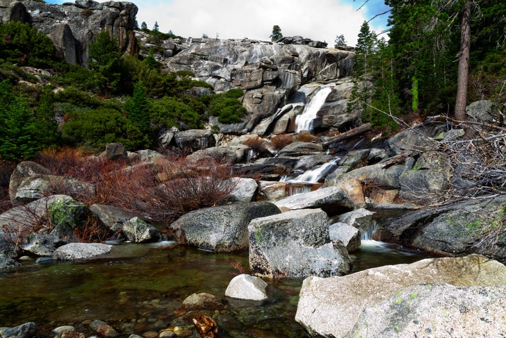
Much like Yosemite Falls, Chilnualna Falls is a beast with so many different tiers, it can’t be seen from a single perspective. Unlike Yosemite Falls, you won’t stand in line for a great photo, as its remote location and tough hike keep the crowds at bay. Chilnualna is a collection of five different cascades that drop a total of 700 feet through a granite gorge. The tallest tier is over 300 feet, but it’s the 50-foot Lower Chilnualna Falls that’s arguably the most dramatic and offers the best photo, as it’s flanked by granite walls dropping into a pretty pool at the bottom. There are plenty of chances to get up close and personal to this falls. You can even scramble up to the next tier to find another drop and pool. Peak runoff in early summer is when it’s most dramatic, but it’s beautiful year round.
How to Get There
Start at the Chilnualna Falls Trailhead off of Chilnualna Falls Road in southern Yosemite. It’s a tough hike that begins along the creek, but quickly starts climbing through the forest via a series of switchbacks. The climbing doesn’t really stop until you reach the falls. All in, you’ll climb 2,500 feet during this 8.5-mile roundtrip hike that doesn’t get a lot of attention, so you won’t need to fight crowds to get your shot.
Watch Our Tips for Visiting Crowded (and Underfunded) National Parks This Summer
Graham Averill is Outside magazine’s national parks columnist. One of his most memorable backpacking trips was inside Yosemite National Park. He recently wrote about the perfect summer road trip through West Virginia.
Graham Averill is Outside’s National Parks columnist, as well as a gear columnist for the magazine, spending most of his time writing about travel and the equipment he uses while traveling.
He grew up in the South before bouncing around the West where he studied at the University of Colorado and fell in love with skiing, surfing, and mountain biking. Eventually he and his wife settled down in the Southern Appalachians because it’s the only place in America where you can get boiled peanuts from a roadside stand.
He’s contributed to a wide range of magazines, from Bike mag to AARP, and he really likes to write stories about pushing his own limits. Also, he jumps at the opportunity to write about his truck.