


Large stretches of the US East Coast are facing large waves as Hurricane Erin churns along the seaboard, spawning rip currents and flooding.
The category two storm, currently over the Atlantic Ocean, is not expected to make landfall in the US, but authorities have cautioned that storm surges and road closures are likely.
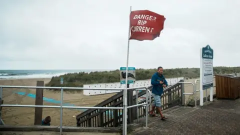
North Carolina is expected to be one of the worst hit areas, although no-swimming advisories have been issued at beaches as far north as New Jersey and Delaware.
Erin has already barrelled through the Caribbean, drenching Puerto Rico, and is packing maximum sustained winds of 105mph (168km/h), said the US National Hurricane Center (NHC).
Waves as high as 30ft (9.14m) are forming off the east coast on Wednesday, bringing high waters to some coastal towns.
“Conditions expected to deteriorate soon in the North Carolina Outer Banks,” the NHC said in its 14:00 EDT (18:00 GMT) update.
Swimming at most coastal beaches is strongly discouraged “due to life-threatening surf and rip currents”.
The Outer Banks, a string of barrier islands off North Carolina, are already bracing for heavy surf and high winds.
Speaking at a news conference on Wednesday, North Carolina Governor Josh Stein warned people to begin preparing for the storm.
“It’s a serious storm,” he said. “No-one should be in the ocean.”
Stein said the state had three “swift-water rescue teams” and 200 National Guard troops ready to help people with boats, aircrafts and other vehicles.
Authorities have ordered mandatory evacuations of Hatteras and Ocracoke amid fears that the main highway linking them to other islands could become impassable.
Stein urged people to take the orders seriously, telling them to “take action now before it’s too late”.
 Reuters
Lily, the hostess of Miller’s Waterfront Restaurant in the Outer Banks town of Nags Head, told the BBC the wind was “starting to pick up” and the weather had become cloudy.
The storm was not currently affecting business, she said, adding that “most weather channels are overreacting” – although she added it might be a different story farther south in Hatteras Island.
At least 60 people were rescued on Monday from rip currents – which flow away from the shore and can quickly pull people into the ocean – at Wrightsville Beach, North Carolina.
Vicki Harrison, who works at the Harbor House Seafood Market on Hatteras Island, said she had chosen not to join those evacuating.
“They evacuated all the tourists on Monday morning, and the residents on Tuesday,” she told the BBC. “But we chose to stay.”
She said her family had lived in Hatteras for 40 years and had to evacuate several times.
“We would have more trouble evacuating than staying,” she said.
“We’re very safe, we’re all hunkered down, we’ve got plenty of food and plenty of water.”
Storm surge warnings are in place in the state from Cape Lookout to Duck.
Beaufort Inlet, North Carolina, to Chincoteague, Virginia, are expected to face possible tropical storm conditions over the next two days.
Meteorologists warn the hurricane is unusually big, with tropical storm winds spanning 230 miles from its core.
On Wednesday and Thursday, the NHC said Erin would move between Bermuda and the US East Coast.